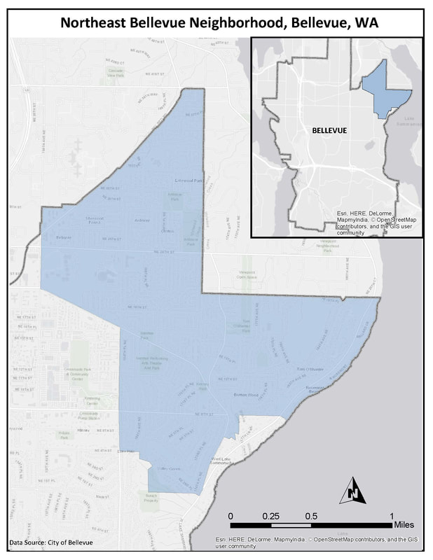
As a component of my urban planning program, a core course focused on applying knowledge and skills to a real-life planning scenario in the city of Bellevue, Washington, through the Livable City Year program. My group's project aimed to analyze walkability and mobility in the neighborhood of Northeast Bellevue. Using a combination of qualitative analysis and spatial analysis using GIS, this project provided insight into problems with mobility in this suburban neighborhood.
For further explanation of this project, the full Executive Summary is included below.
For further explanation of this project, the full Executive Summary is included below.
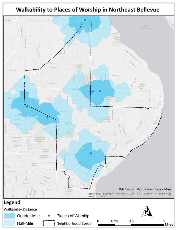
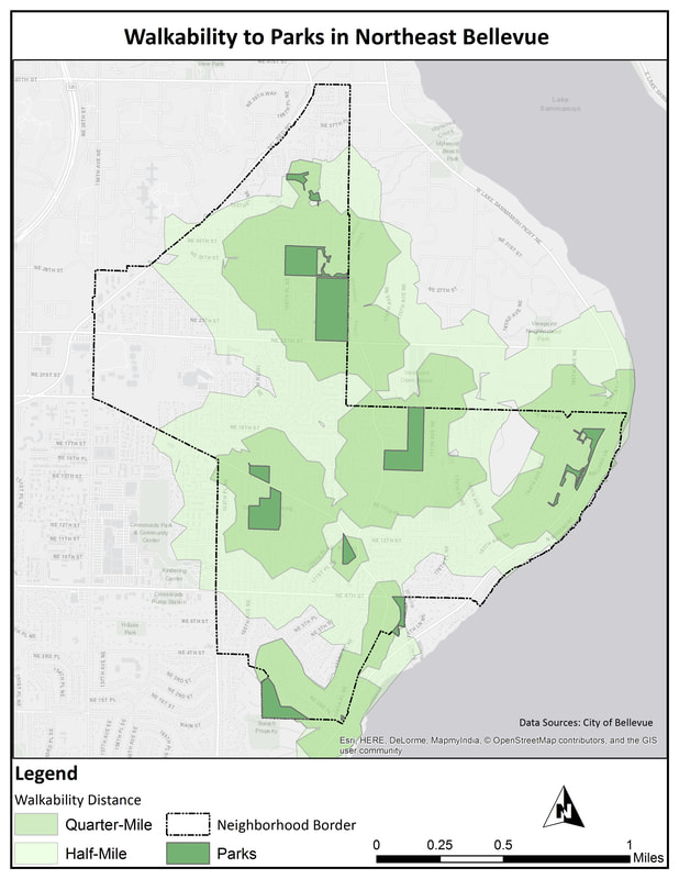
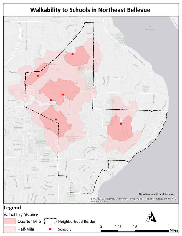
For the spatial analysis component of this project, we identified three main types of community assets that were important to the neighborhood: schools, parks, and places of worship. In order to evaluate walkability to these assets, I performed a network analysis to identify the areas of the neighborhood that were walkable to these sites within a quarter-mile and half-mile.
Executive Summary
This project serves to look at mobility in Northeast Bellevue, Washington through the Livable City Year program, in conjunction with the University of Washington Urban Design and Planning department. This project is being done to analyze the general mobility, and specifically the walkability and bikeability of the neighborhood. The goal is to find a way to increase accessibility, safety, and efficiency of mobility in the neighborhood. Our research is being done in an effort to identify areas for improvement and create a list of implementations suggestions. This project works to satisfy the existing Bike and Pedestrian Plan for the City of Bellevue goals. Further, and instrumentally, this project serves as a way for citizen engagement on the topic to occur and be represented in the neighborhood, facilitating community-based planning in Bellevue, which is important when considering potential planning that will affect daily life for citizens.
Through the various kinds of research methods, this project provided insight to problems and solutions for mobility in Northeast Bellevue. The first portion of research was to look at the City of Bellevue’s existing Bike and Pedestrian Plan, which provided background and context for what the City is already doing to plan for mobility. Next, a focus group was held to understand how residents of Northeast Bellevue feel about mobility and walkability in their neighborhood. This provided a great amount of insight to how the citizens interact with their local environment. The focus group participants highlighted the aspects of mobility they liked in their neighborhood. They emphasized the quiet, secluded feel of the neighborhood, and the location of the neighborhood relative to other areas of Bellevue. The participants also spoke to some aspects of mobility in their neighborhood that need improvement, highlighting the congestion along certain arterials and lack of safe and connected bike and pedestrian infrastructure.
The next element of research was to conduct a Gehl Analysis, which is a qualitative, human-scale analysis on the neighborhood, which aimed to provide a more experience-based perspective of the area. Three chosen study sites were analyzed on a scale of one to three based on twelve criteria of urban quality. We found that certain areas of the neighborhood are more friendly to pedestrians and bicyclists than others due to a variety of factors, including the presence of sidewalks, condition of infrastructure, street lighting, the surrounding natural environment, protection from traffic, and other urban design elements. The lowest-scoring site scored a 1.5 due to a lack of sidewalk connectivity on main arterials and side streets, lack of safe crosswalks at large intersections, and steep slopes. The second site scored a 2.2 due to the fact that there were some busy roads with limited pedestrian infrastructure, sidewalks, and limited lighting, but there were pedestrian-friendly trails in Tam O’ Shanter Park that increased the overall score. The highest-scoring site, however, scored a 2.9 due to the wide sidewalks, access to green space and the natural environment surrounding the Tam O’ Shanter Golf Course, and the consideration for accessible infrastructure.
Finally, using the information learned from the previous methods, we conducted a spatial analysis to provide a different perspective on mobility in Northeast Bellevue. Geographic Information Systems software was used to determine service areas for schools, parks, and places of worship. This analysis illustrates the areas of the neighborhood that are walkable within quarter- and half-mile radiuses along the street and trail networks. This research found that while most areas of the neighborhood are walkable to parks, there are many areas where walking to school or a place of worship is not an option. Additionally, even if a destination is near by, it is not necessarily easy to walk to due to the complex street network.
The above results yield certain implementation suggestions and strategies for the City of Bellevue that work to best improve mobility in the Northeast Bellevue neighborhood while incorporating research and the existing Bike and Pedestrian Plan. Common threads inform our suggestions, which are listed below:
The full report, which includes methodology, additional maps, findings, and recommendations, is accessible here:
This project serves to look at mobility in Northeast Bellevue, Washington through the Livable City Year program, in conjunction with the University of Washington Urban Design and Planning department. This project is being done to analyze the general mobility, and specifically the walkability and bikeability of the neighborhood. The goal is to find a way to increase accessibility, safety, and efficiency of mobility in the neighborhood. Our research is being done in an effort to identify areas for improvement and create a list of implementations suggestions. This project works to satisfy the existing Bike and Pedestrian Plan for the City of Bellevue goals. Further, and instrumentally, this project serves as a way for citizen engagement on the topic to occur and be represented in the neighborhood, facilitating community-based planning in Bellevue, which is important when considering potential planning that will affect daily life for citizens.
Through the various kinds of research methods, this project provided insight to problems and solutions for mobility in Northeast Bellevue. The first portion of research was to look at the City of Bellevue’s existing Bike and Pedestrian Plan, which provided background and context for what the City is already doing to plan for mobility. Next, a focus group was held to understand how residents of Northeast Bellevue feel about mobility and walkability in their neighborhood. This provided a great amount of insight to how the citizens interact with their local environment. The focus group participants highlighted the aspects of mobility they liked in their neighborhood. They emphasized the quiet, secluded feel of the neighborhood, and the location of the neighborhood relative to other areas of Bellevue. The participants also spoke to some aspects of mobility in their neighborhood that need improvement, highlighting the congestion along certain arterials and lack of safe and connected bike and pedestrian infrastructure.
The next element of research was to conduct a Gehl Analysis, which is a qualitative, human-scale analysis on the neighborhood, which aimed to provide a more experience-based perspective of the area. Three chosen study sites were analyzed on a scale of one to three based on twelve criteria of urban quality. We found that certain areas of the neighborhood are more friendly to pedestrians and bicyclists than others due to a variety of factors, including the presence of sidewalks, condition of infrastructure, street lighting, the surrounding natural environment, protection from traffic, and other urban design elements. The lowest-scoring site scored a 1.5 due to a lack of sidewalk connectivity on main arterials and side streets, lack of safe crosswalks at large intersections, and steep slopes. The second site scored a 2.2 due to the fact that there were some busy roads with limited pedestrian infrastructure, sidewalks, and limited lighting, but there were pedestrian-friendly trails in Tam O’ Shanter Park that increased the overall score. The highest-scoring site, however, scored a 2.9 due to the wide sidewalks, access to green space and the natural environment surrounding the Tam O’ Shanter Golf Course, and the consideration for accessible infrastructure.
Finally, using the information learned from the previous methods, we conducted a spatial analysis to provide a different perspective on mobility in Northeast Bellevue. Geographic Information Systems software was used to determine service areas for schools, parks, and places of worship. This analysis illustrates the areas of the neighborhood that are walkable within quarter- and half-mile radiuses along the street and trail networks. This research found that while most areas of the neighborhood are walkable to parks, there are many areas where walking to school or a place of worship is not an option. Additionally, even if a destination is near by, it is not necessarily easy to walk to due to the complex street network.
The above results yield certain implementation suggestions and strategies for the City of Bellevue that work to best improve mobility in the Northeast Bellevue neighborhood while incorporating research and the existing Bike and Pedestrian Plan. Common threads inform our suggestions, which are listed below:
- Provide connectivity of walking and biking paths via improved infrastructure.
- Increase feelings of safety associated with mobility in Northeast Bellevue.
- Normalize walking and biking as viable methods of transportation (made possible by infrastructure).
- Ensure that suburban lifestyle can coexist with mobility measures.
The full report, which includes methodology, additional maps, findings, and recommendations, is accessible here:
